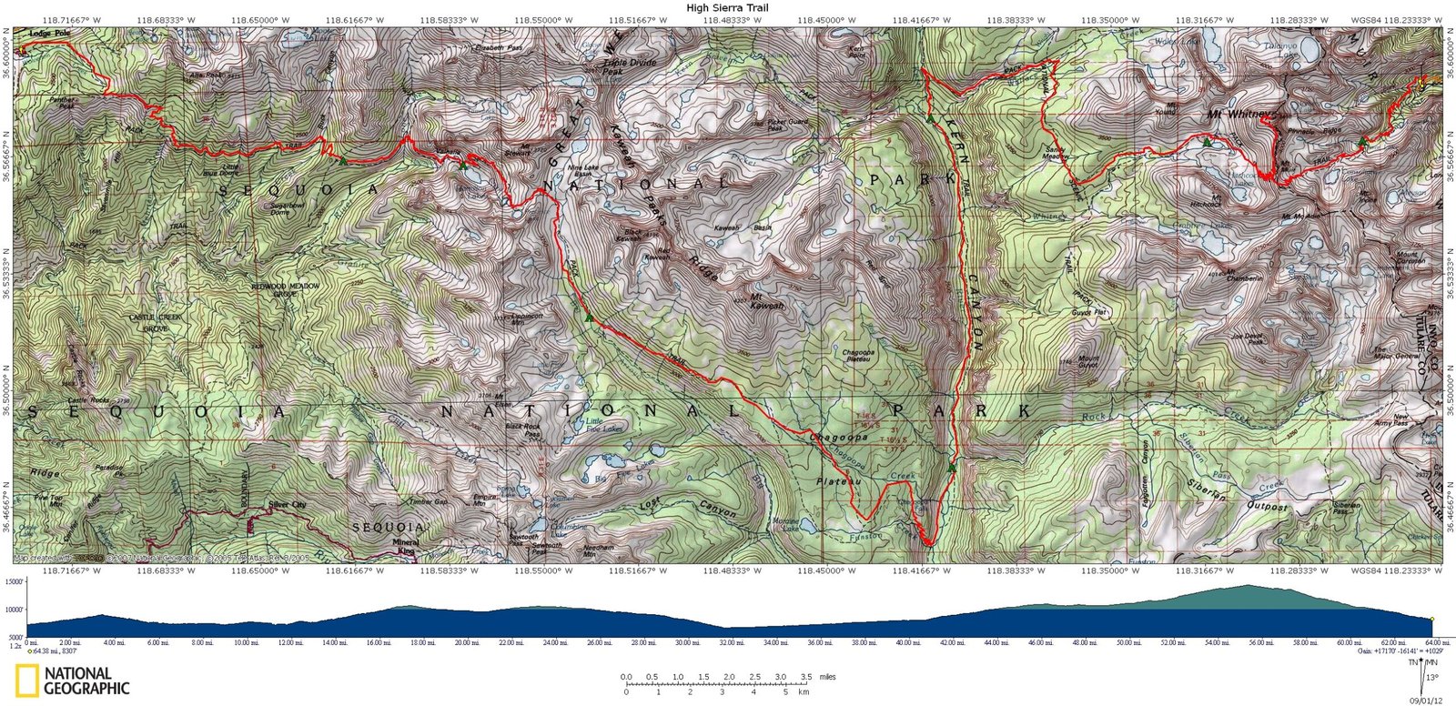
Right out of camp I was heading up switchbacks out of the canyon. You can see from the below Contour map how the trail heads SE and starts bisecting contour elevation lines. It was another rough morning. They are taking there toll on me and I know I still got a few big ones in front of me on subsequent days

I finally got up on top and instead of taking the side trip down to Moraine Lake I opted to keep on the main trail as I might want to get some miles under my feet today.


Below i spotted a Jackrabbit. I am not sure which variety because I had kept my 5 lb guide to flora and fauna in my pack and tomorrow I would go one step further and deposit it, along with my John Muir book, in a bear box. I needed to drop weight and I figured maybe people hiking the trail could trade it back and forth as they hiked each way.


After reaching the top and walking along a plateau for a bit, I dropped down through an old fire area.

Then I hit a steep series of switchbacks. I was glad not to be going back up these and it looked painful and boring.


Looking into the Kern Valley as I further worked down towards the river. I was running low on water, but I knew the river was below me and there was a campsite there as well.


When I got to the bottom there was a trail sign that directed either to the campsite or continuing north up the river. I was kinda pissed because I thought I would come out at the riverside. This means I would either continue with the trail and hope for water soon or go the opposite way to get water. I hate adding unnecessary miles to a hike so I opted to continue towards Kern Hot Springs with no water


I also wanted to keep going even though this was where I was supposed to camp because I figured the vertical part of the hike was coming up and any miles I could get ahead of the game I could take my time during the more difficult sections.
I reached the Kern River Hot Springs and set up camp along the river.

Below is a shot of the hot springs. In the next couple shots you can see how they have piped the water into a cistern where you can then plug it to create a bathtub of sorts. I filled up the cement tub and got in but it was too hot for a summer day. I should say that I like to be cold most of the time and have never really been a fan of hot tubs.


Below is a shot of how they made the tub outflow into the river into a rock tub. This makes the river water, which is normally very cold, a little more bearable.

I took the opportunity to use my drybag as a washing machine, filling it with soap and water and my dirty clothes. Avoiding dumping the soap into the river, I dumped in the woods and filled bag up again with clean water. I then laid the clothes out on the rocks to dry while I laid out for some R & R.


The next day I was scheduled to only hike 7 miles to Junction Meadow, but I really was trying to get up the next ridge and make it to Wallace Creek.

The morning was a pretty gradual ascent up the river. I nice calm before the storm.


I reached junction Meadow and stopped for a Clif bar. I was starting to feel some nausea. I had not attributed it to altitude at this point. i thought it might be a result of the new chlorine mix I was using to purify the water. As a result I did not eat breakfast and would only get one bar down until dinner. Not enough calories to sustain the amount of work I was doing each day. It was not until I ran into other hikers with similar symptoms that I was sure it was due to altitude. In the future i will get an Rx for Acetazolamide (Diamox) before I go.

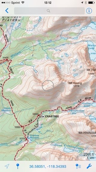
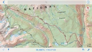
Below is a map of the hike in front of me up to Wallace Creek. It is 1.1 miles to a junction then 3 miles further to 10405 ft. Again, looking at the contour intervals you can see that all the lines are bunched up and the red line bisects them....A very bad indicator for me. I really had to sit down and gather my strength. Too much summer floating in the river, beer drinking, high altitude sickness and not enough time in the gym were making this more of a struggle then I had anticipated.

Below was my first sign indicating Mt Whitney being 16mi away. My ultimate goal.


I finally made it to the first junction 1 mile up. I was dead to the world.


The next 3 miles I stopped multiple times to lean against trees, hug rocks, or just sit on the ground. Every time I stopped and restarted it took about 5 steps to feel exhausted again. I don't really know if my muscles were weak or they just were not getting enough oxygen due to thin air. Regardless I felt like a bum until i got to the top and talked to the other campers at Wallace and heard the same story.


Until Tomorrow
Darren