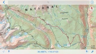
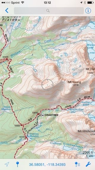
Today is a short day by design. As seen below on map I am hiking from the top left corner South to Crabtree and then uphill and East to Guitar Lake for the night. It is about 8 miles. There I will camp for the night and attempt to summit the next day and then down the other side back to civilization.


At Crabtree there was a box filled with Wag Bags. To those who are not familiar there are a sort of Fecal Containment Device (medical terminology). I have now left the Sequoia NP and am entering John Muir Wilderness near the Whitney Portal. You are not allowed to go to the bathroom and dig a hole but rather have to carry it out. I grabbed a bag, but I was planning on doing everything possible not to use it.


I arrived at Guitar lake (shaped like a guitar) around 1pm and found a spot near 5 guys from San Francisco. I wanted to arrive later in the day to avoid the direct sun, but I was too anxious to get to my destination. I immediately dove into the lake after setting down my gear.
The group of us sat around all day at 12K feet trying to put down some food. The High Sierra Trail had combined with the John Muir Trail out of Yosemite and the Pacific Crest Trail running entire vertical length of US. So this lake was crowded with people looking to make the summit. It turns out everyone was leaving at 1am to make the top by 5am sunrise. We talked about leaving at 4am.


This is a view of the moon and the ridge we would head towards in the morning.


It is basically a 2.5 mile run of switchbacks up to the Trail Crest. From there, after dropping my pack, I would continue the 1.8 miles to the summit. After that retrace my back and head down the other side.

We had planned on leaving at 4am but everyone was awake at 1am so we decided to head out as a group. Looking up the ridge was just a line of head lamps. The sad part was that we had so far to go we could not distinguish stars from lights.


Here is the trail. Basically a foot wide with a pleasant drop to the left.

I finally reached the Trail Crest with a short time to sunrise. It was not easy. You just keep your head down and look one foot in front of the next. We dropped packs. It felt so liberating as we headed off along the ridge, glimpsing sunrise through the gaps

I overexposed the below shot to get a more clear shot in the dark. The one below is more accurate as to what it looked like at the time.


We finally saw the hut at the top. Turns out a group of 4 slept in that thing last night. I was freezing without proper jacket and gloves. Nausea was getting bad at 14500 feet. I just wanted to grab some shots and get back down.


Below is a trail register to prove you made it. I think they just throw these away every year as the dates did not go back too far. It would be cool if they scanned it and put it online so you could look it up in 20 years.


Below is the route from my SPOT locator beacon throughout the hike. The picture below that is a satellite view of the top (you can see the hut) with my positions overlaid on it.


Below was something cool. This is a benchmark. It turns out the US puts these metal discs all over the country to mark fixed measured points. This measures the mountain top. There is actually a few of them up here as they keep remeasuring as the mountain slowly grows. You can find them all over your city. Some measure longitude and latitude so surveyors can start from a "known" spot
Here is a Map where you can search for them: Click Here

When I got down I bought a replica to fix into a block of wood to commemorate the hike.


When I got to Trail Crest I grabbed my back and took of quickly down the last 8.5 miles to the trailhead

Here is a shot of Guitar Lake, where I stayed last night, from Trail Crest.


Coming down you can see what is called the "99 Switchbacks" on the picture below. The trail on this side was flooded with people due to easier access. People mostly hike up to the bottom of the switchbacks and then hike the last couple miles the following day. It was a wasteland of gear and human excrement. It felt like the scene in The Ten Commandments when Charleston Heston goes up to get the tablets and all the people are down below worshiping golden gods, getting drunk and having orgies.


Here is a shot of the entrance from the Whitney Portal

All anyone talks about on the trail is getting a Cheeseburger from the store at the bottom. I wolfed down one now that my appetite was back, along with 3 pops and an ice cream cone. It felt like pregnancy cravings.

The rest of my group from Guitar Lake came down a couple hours later. Their friend had met them at the parking lot with food and beer. They were kind enough to not only share but give me a ride into Lone Pine, a town 10 miles further down the road.

I got one of the last rooms because the town was hosting a ultramarathon where people were running from the lowest spot in the US (Death Valley) to the highest spot (Mt Whitney)...crazy. I spent the night in a Best Western. I called the front desk to ask if there was any food nearby....no. Was there anywhere that delivered...no. Where there any vending machines...no. Was there a taxi service...no. I guess I was not eating tonight I guess.
I was scheduled to take a bus from a McDonalds parking lot up to Reno in 2 days, but i was able to move it to tomorrow at 6am. I woke up at 4 am, scavenged the breakfast buffet and walked the couple miles to the bus stop for 6 hr ride to Reno.

The next issue was I was supposed to fly out in 2 days, but was hoping to get out today. I did not want to change my flight in advance because my bus was to arrive at the airport at Noon and flight was to leave at 1pm. I wasnt sure I could make it. Fortunately the flight was delayed and I paid the $200 to get out early. The minute I went up in the air I got sick. During my layover in Denver I popped some Dramamine and was acting like I was high for next few hours but at least no nausea.
I landed in Detroit at 1am and used the Uber car service for the first time. I was utterly confused and probably cancelled 5 rides in error before figuring out the way it worked. It seemed pretty slick but since I only paid $30 for 40 minute ride I dont think I will be starting my own Uber service anytime soon.
The more days that pass after my trip the more I feel like might try something like this again, but for sure I will only be carrying the very few essentials.
One final quote from the book River Horse:
"Pilotis (character in book) had reported an incapacity at home for dealing with the mundane requirements of contemporary life, an unwillingness to tolerate “pissants and nitwits”, an enervating awareness that, without the invigoration of ever-present threats, life turns vapid and is beneath respect. For all the river took away from us, it returned the greatest gift – a clean and unassailable purpose to existence. We lived to go another mile, to try to encounter it fully so memory would register it deeply, and to stay around long enough for the next mile and a reward of repose at the end of the day."
As I meandered around town the next few days I had these same thoughts in my heads. I always have these thoughts in my heads when I return from a long trip abroad. I feel like an outsider, watching the rats in the maze.
Until Next Time
Darren